Digital Maps for Hunting
Overview
Digital map technology has never been better for hunters. Improvements in smartphone technology, streaming speed, and hunter-specific software provide hunters with the tools to view, create ,share, and print a variety of maps and views. Most digital maps require an annual subscription rate and offer both online and offline modes. Some digital maps are still available as SD card downloads if that’s more your speed. Outdoor Life recently covered some of the best online mapping products, and we’re going to weigh in as well with the pros, cons, and strategies of using digital maps.
Digital Map Advantages
- Same maps on all your devices
With digital maps, you can move freely back and forth between multiple devices and use the same map, meaning all your waypoints, notes, and other saved data can exist on multiple devices. That waypoint of a huge elk rub that you marked in the field using your smartphone and ONX maps? You can pull up your ONX account while back home on your desktop and see that same waypoint on a bigger screen. Or, if you are e-scouting from home and create several pins for areas that look promising for elk sign, you can easily access those waypoints from your mobile device. Mapping tactics today are fluid, back-and-forth, and downright powerful for the modern hunter. - Sharing Waypoints
Digital maps make it super simple to share waypoints with hunting buddies. By text message, you can quickly show a buddy your current location while out in the field, plan a rendezvous point, or share a really nice duck hunting hole that you visited the day before. - Land Ownership Views
This is the single greatest advantage to digital maps — they offer (mostly) up to date views of property ownership lines. When hunting, it’s important to know whether you are on on property where it’s permissible to hunt. Having a digital map with current property ownership lines from county tax plats is a game-changer for hunters. - Flexibility
You can zoom, toggle through layers, add and delete waypoints, make notes, draw lines, and share GPS tracks with friends.
Digital Map Disadvantages
- High Cost
Online subscription fees add up. Annual contracts with ONX cost $99 for all 50 states, and other companies charge equivalent rates. In years past, it might cost $30-50 to buy a collection of paper maps that would serve you well for years. Today, plan to spend double that annually to stay current with the latest online mapping technology. - Small Field of View
Viewing an entire hunt unit on a 2 x 4″ phone screen is not very useful. For this reason, paper maps should still have a place in your hunting map repertoire. Without them, you’ll miss out on big picture views and analysis that conventional paper maps allow.
What Device?
You’ll need to pick a device — or several — for viewing and managing your digital maps. Here are the most common options for hunters.
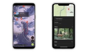
- Smartphones
Smartphones are by far the most common digital map device. Many people already have a smartphone, so it makes sense that companies would put their maps on this technology. Plus, the GPS device in a smartphone is often equal or better to the GPS device in a dedicated GPS unit. - Handheld GPS Units
Before smartphones, these handheld units were once the only option for GPS tracking in the field. To this day, companies such as Garmin still produce handheld GSP units. They are reliable, standalone units and generally accept a micro SD card that you can use to upload ONX maps or your own custom maps. Unfortunately, the screens and buttons on handheld GPS devices are woefully behind the times compared to smartphones. They can be downright frustrating to use. - Tablets
While not as common, tablets are really the ideal digital map platform for hunters. They offer a significantly larger field of view compared to smartphones, but are still portable enough to pack. For the serious hunter willing to pay for an extra device, tablets are worth considering.
Mapping Companies
- ONX Maps
This company is the current market leader in providing digital maps with tons of useful layers and features for hunters. In particular, ONX was one of the first digital map companies to show property ownership boundaries — both public and private. Other companies have followed, but ONX remains a leader in the digital map world for hunters and is a good choice for your desktop and mobile app. - GAIA Gps
Gaia GPS is no-nonsense online mapping company that offers an affordable, layer-rich option for hunters who don’t need a lot of visual bells and whistles. GAIA Gps also has a property ownership layer, which is crucial for hunters. - HuntStand
This company caters to tree stand hunter nationwide, because some of their features help hunters pick stand locations based on wind direction and organize deer hunting properties. Still, Huntstand has some other features that might make it a candidate for your all-around hunt map software. - Google Earth Pro
Available as a desktop or web platform, Google Earth is completely free and offers some of the best visuals compared to all other digital map softwares. The 3D rendering is fantastic. However, for hunting Google Earth is not a complete mapping solution because it lacks key layers and waypoint data such as property ownership lines and trails. For that, you’ll want to purchase another program this list. - GoHunt Maps
Created by hardcore backcountry hunters, GoHunt was one of the first companies to offer interactive 3D rendering and “collections” on its hunt maps. These maps are available to anyone who buys a GoHunt Insider subscription, which also offers tons of analysis on out-of-state draw odds for controlled hunts and tips for finding success as a backcountry hunter in the West. Not cheap, but worth the money if you are just starting out and want to learn the ropes of hunting big game in the west. Other companies have since followed GoHunts lead and are offering better 3D rendering. Because even though reading old-school topo lines is a valuable skill, seeing your hunt area in high-definition 3D is useful for seeing glassing nobs, dark canyons, and travel routes. - Avenza
Avenza specializes in geospatial PDF files that users can customize to their needs. Generally, this platform is a more affordable option than ONX and other boutique online mapping solutions, but will require more manual work to configure maps the way you want.
Quizzes